We offer a number of classes for both the current BSc/MSc program as well as for the old 'Diplom' studies (until SS 2012). You can find an up-to-date to date list of all classes in JOGU-StINe, and downloadable material from the download page (restricted to Uni-Mainz students).
Introduction to Geophysics
[BSc students; always in the SS].
 You will learn the basics of geophysics and how we can apply geophysical methods to understand the large-scale dynamics of the Earth on one hand but also how we can apply it to understand the shallow subsurface. Topics include the shape of the earth, gravimetry, (earthquake) seismology, refraction and reflection seismology, plate tectonics and geodynamics and geoelectrics and geomagnetics. Field experiments are performed to demonstrate how measurements are done in practice, and weekly exercises help to understand the subject.
Hydrogeology
[BSc students; always in the SS].
You will learn the basics of hydrogeology and flow if groundwater on the Earth, including practical examples.
Geostatistics 2
[BSc students; starting in the WS, project in the SS].
You will learn the basics of programming with MATLAB/Octave, image analysis and statistical analysis using R. In the first part of the module we focuss on the basics of programming and solve a whole range of Earth-Sciences related problems (from rock-fall to diffusion of temperature). You will also learn how to create graphical user interfaces, perform image analysis to, for example, automatically analyse grain size distributions. In the second part of the module, you will work on a project in a team.
Introduction to quantitative geosciences.
 Numerical methods play an increasingly important role in our (scientific) life. Here, you will learn the basics of the finite difference method and apply it to solve partial differential equations that describe various geological processes such as modelling of earthquakes, groundwater flow and modelling of pollution in the subsurface, geothermics.
Geodynamics
[MSc-students; Summer-semester].
 The solid Earth is a dynamical system that has evolved over billions of years which resulted in the formation of mountain belts, subduction zones, volcanoes etc. The dynamics of the lithosphere is intimately coupled to the dynamics of the underlying convecting mantle. Yet, why is the Earth the only terrestrial planet that currently has plate tectonics? What is the coupling between erosion and deformation of the lithosphere? In this class we will look at what we know about the physical processes that control the dynamics of the Earth.
Geoscientific Data Visualization
[MSc-students; Winter-semester].
Creating maps, and accessing openly available geoscientific data such as earthquakes, topography, precipitation are important tasks for any geoscientist. In this class, you will learn how to use the open-source software GMT to create professional maps and interpolate and analyse data. You will also lern how to manipulate the data (for example interpolate it on a different grid, remiove trends etc.) and you will learn some basic linux skills along the way.
Geophysical Modelling
[MSc students; Winter-semester].
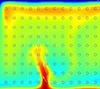
 In this module you will learn to use state-of-the art geodynamic software to model geological processes (such as the formation of fold-and thrust belts, or migration of melt through the lithosphere and eruption in a volcano). The main emphasis is on going from a geological conceptual model (or cartoon) to a quantitative computer model that takes the physics of geological processes into account. Along the way you will learn scientific visualisation, the use of high-performance computers, understanding the physics of the Earth, as well as soft skills such presenting your scientific results. The topics change on a yearly basis, but are typically research problems that have not been solved yet.
Orogenic systems module
[MSc-students; Summer-semester].
How are plates deformed and how does continental collision result in mountain belts? These questions are heart of solid-Earth geology and can only be addressed with an interdisciplinary approach which requires an understanding of (field) geology, tectonics, structural and metamorphic geology, petrology, laboratory experiments as well as some understanding of (geo)-physics and geodynamics. In this module students will learn to incorporate data from all these subdisciplines to better understand the Earth. The focus of the module is on orogenic belts, but the approaches learned are useful to tackle any geoscientific question.
Advanced computational geodynamics
[MSc-students Computational Sciences; Winter-semester].
 How do we model the Earth in a quantitive manner? Our research group is quite active in that field and in this class we will pass on some of the latest research results. Topics include things such as programming with the finite element methods, variable viscosity Stokes flow, benchmarking software, but also more advanced topics such as implementing nonlinear rheologies, visoelasticity, plasticity, high performance computing, multigrid and scalable iterative solvers.
Numerical modelling and analysis of surface processes
 Erosion shapes mountain belts, but what can we actually learn for analysing landscapes? In this block-course, students will learn to analyse existing landscapes, as well as some of the theory behind modelling surface processes. You will also use a surface processes model to get a better understanding of the physics of erosion.